Showing posts with label Trekking. Show all posts

Saturday, January 2, 2016

Camping at Northern NSW

Heading out on Boxing day full of xmas cheer, Chris and I headed south-west into New South Wales for a few days of camping, hiking and kayaking.


We arrived at Urbenville just after lunch and decided to hike to a new climbing spot that afternoon while the weather was fine. The route descriptions were pretty good and we followed faint motorcycle tracks before a step, ferny section lead steeply up to the rock wall. Kicking away the leeches that had attached themselves to Chris' shoes, we checked out the routes and rested before heading back down the hill.


Once back at the car we decided to go for a swim at Tooloom Falls, and wash away the sweat and grime. We scrambled down the rock cliff and had a great swim in and around the falls. Noting the the adjacent camp site was full, we drove in to town to have dinner at the local pub, and watched the day turn to night.


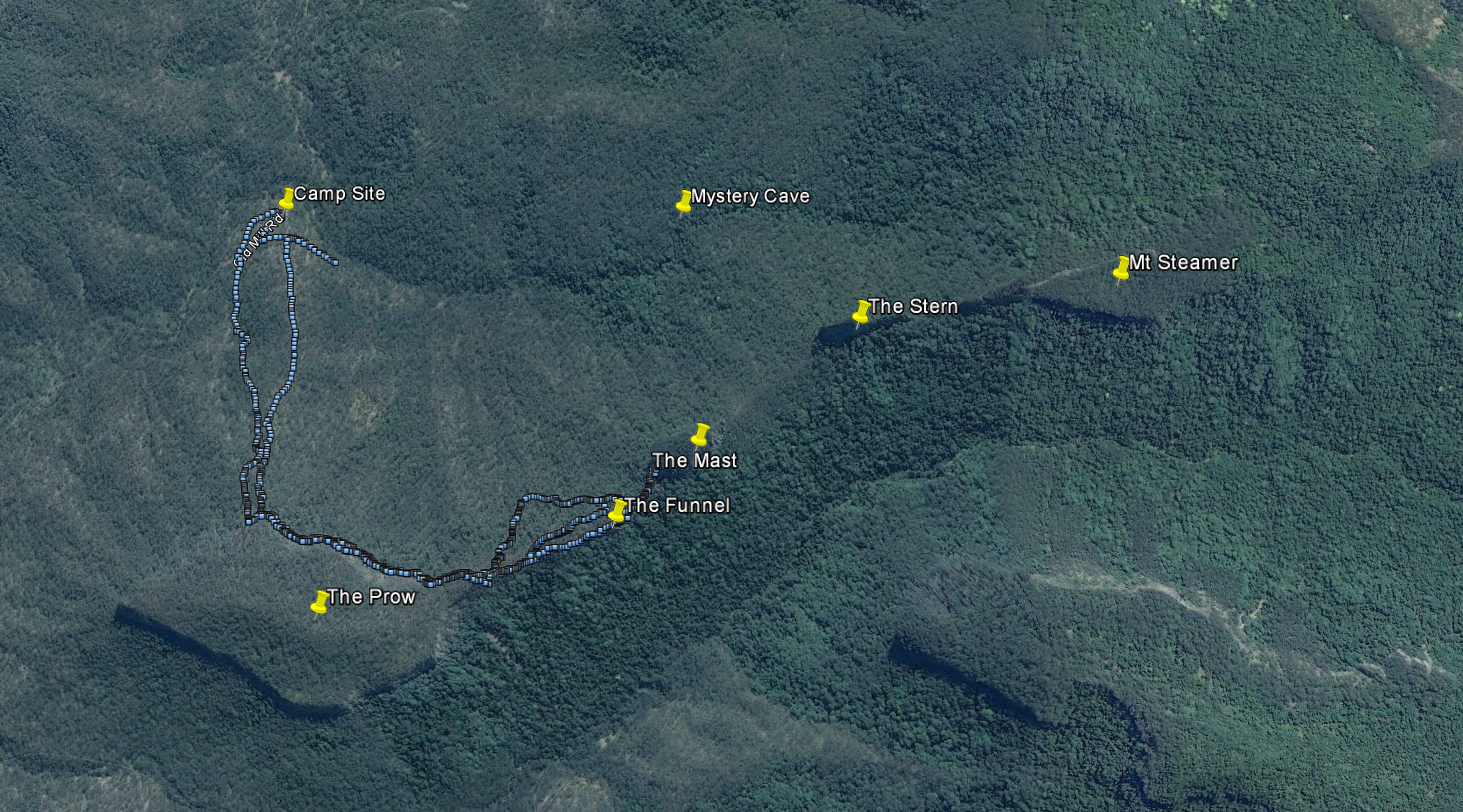
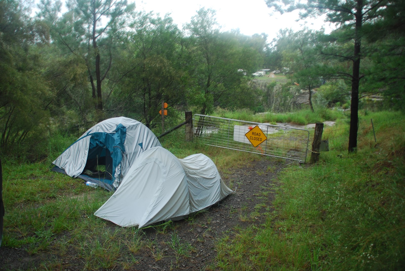
That night, we decided to explore Yabbra State Forest a little more, to try and find a suitable place to camp for the night. We drove past 'Battery Hill' a small section of rock we planned to climb the next day. Soon the narrow track became overgrown, and before long I was driving through metre high grass unsure of where the track continued. Sticking to the mountain we found the track again, following it all the way around to where we started from! Feeling tired and not seeing any other suitable sights during the day, we parked on the other side of the waterfall on an old rocky road and set our tents up as best we could.

No sooner had we finished then the rain kicked it. We hastily climbed into our tents, tried to get comfy on the rocky ground, and fell asleep to the rain getting heavier. It continued through the night, by morning it had stopped but it was clear that we wouldn't be climbing that day.


Plan B involved driving a little further south to a place called Paddys Flat, nestled on the banks of the upper Clarence River. It was the site of many previous camping adventures, and an epic winter kayak trip earlier in the year.

After an early lunch and setting up camp to dry a few things out, Chris and I set off down the Clarence River. The recent rain had stirred up the water, but it was pleasant paddling downstream. We navigated the small rapids without issue, but as we got further downstream the skies darkened.


Keeping in mind we would need to paddle all the way upstream back to camp, we turned around after a few hours and started back. Soon after, the skies opened up. Lightly at first, but the rain soon grew heavy. The river swelled a little, and it was noticeably harder paddling against the extra current.


The rain eased as we arrived back to camp, we set about starting a fire and drying things as best we could. At least our tents were properly pitched so our bedding was dry. The fire was soon blazing, and we say around in the light drizzle enjoying a beer and a hot dinner. Night came and with it more rain, so we retired to our tents for the night, a lot more comfortable on a bed of thick grass beneath.


It was hot and humid the next morning as we packed up camp, still no climbing to be done due to the rain, so as we started back to Brisbane we made a slight detour for one last hike. We stopped at Mt Maroon (the site of many great adventures) and started up the steep summit track. We made good time and arrived at the top after lunch, drenched under the hot sun. It was very windy at the top, so after a moment to enjoy the vista and a short rest we started back down.


A few hours later we were back home, another great trip away. It was a shame that we couldn't get any climbing in, but we more than made up for it with some great hiking and kayaking. A trip to be repeated soon.

More photos here


Monday, November 23, 2015

Hiking Mt Flinders

On the way home from Sundown National Park last week, Chris and I spied an interesting looking mountain and decided to one day return to check it out.

After reading up on Mt Flinders, which hosts some pretty tough rock climbing in a secret cave, we decided to give it a shot. In some ways we were lucky, Sunday was grey and overcast, but that kept the heat down compared to the sweltering 35 degrees the day before. Unfortunately our view of the Scenic Rim from the summit would be lessened, but we went up it anyway!

Chris took his three year old daughter along for the trip, after reaching the car park he saddled up and we got hiking.

It was a pretty straight forward walk but very step in sections. We finally got to the top, Josephine helping with route finding by spotting all the trail markers and tape. 

While the views were nice even under the grey skies, they were marred by the large communications tower constructed on the peak. 

We did the 6 kilometer round trip in about 3 and a half hours, including a nice rest at the top. We arrived back to the car just as it was getting dark and set off back to Brisbane.

A fun hike close to Brisbane, a great effort by Chris, and Josephine was great company.

More photos here


Saturday, November 7, 2015

Return to the Steamers

My first attempt at finding the Steamers rock formation didn't go quite as planned so Naz and I returned to make amends. Knowing that a second attempt would take the better part of the day we decided to drive down on Friday night so as to awake early on Saturday morning and get started early.


Leaving Brisbane we drove towards an impressive lightning show as a large storm moved through Warwick, huge thick bolts of lightning constantly illuminated the encroaching front, we drove through heavy rain but as we approached Emu Vale the skies cleared.

That still left muddy tracks and swollen river in between us and our camp site, luckily Naz's Pajero was up for the challenge. He had water over the bonnet a couple of times, and did some four-wheel drifting around some of the muddier corners (at low speed, the greasy mud made the tyres like slicks) but we arrived at a clearing late on Friday night. By the time we had set the tents up, relaxed over a beer, and settled on a plan of attack for Saturday is was past midnight. Time for bed.

Daylight was streaming through the tents as we awoke the next morning, we roused from our sleeping bag to a chill in the air, mist on our breaths. It wasn't yet 6 AM, but sleep was elusive so we brewed a big pot of coffee and started the day.


Once the sun crested the surrounding mountain range the day warmed, and we set off towards 'The Prow' rock formation, the most western of the five features. We followed a faint track towards the imposing rock seen towering through the canopy, it soon became quite steep but we easily found our way up to where we needed to be.


From there it was just a matter or following the rock face east until we reached a saddle where we could ascend to 'The Funnel'. This was easier said than done, we spent the next hour rock hopping, scrambling, and trying to stay as high as possible avoiding the occasional steep drop off below. We made good time and before long we had climbed to the next formation and were rewarded with a stunning view.


We stopped for second breakfasts before trying to find a way further west to 'The Mast'. Not being able to find a path down the ridge we backtracked and looked for a way to follow along the lower cliff face. Nothing was obvious so we decided to go off-track (usually when the trouble begins) but after zig-zagging down the scree slope we found a solid boulder field that we could use to ascend back the ridge.


We were back on track and stopped for another break at 'The Mast', a formidable rock outcrop. Walking around the base, I couldn't help but notice the potential for some amazing rock climbing... Something for the future perhaps. Even though the trail in this area became quite defined we decided not to continue further to 'The Stern' and 'Mt Steamer' but to retrace our steps. We wearily forged a path along the rock face all the way back to 'The Prow' before heading back down to mountain.


Seven and a half hours later we were back at camp, sweaty, dirty and tired. Luckily, the night's rainfall had left the nearby stream swollen and raging with cold, clear water. A short dip in the frigid water was revitalising, and with another fresh cup of coffee brewing we were able to pack up camp and set back off home.


We stopped off at Warwick for some delicious pizzas before heading back over the range to Brisbane. For the second time that weekend we drove towards a lightening storm but once again missed the worst of it.


There is still plenty to see at 'The Steamers', we will return again (hopefully after a heavy storm) to explore more of this amazing area.

More photos here


Saturday, October 31, 2015

Hiking Mt Greville and Spicers Gap

Feeling the urge to get out of the city, I decided to go for a hike at Mt Greville. I drove under dark clouds and overcast skies out towards the Cunningham Gap and turned off just before the range.

I have climbed at Mt Greville a few times, but in the absence of a climbing partner I decided to try some of the other trails. I started up the aptly named 'Palm Gorge' which wound steadily higher through lush undergrowth, between narrow gorges, and under many tall palms.


After a few sweaty hours I made it to the top, and sat down for some water and snacks. I met another group of hikers coming from the 'Waterfall Gorge' trail. Heeding their advice I decided not to continue the path they had taken as route finding was much more difficult on the way down. 

I could have had trouble locating a few important sections (such as the wire ladder up a short rock face) and some slippery slabby sections would be a bit too dangerous hiking my myself if an accident had happened.

I turned around and went back down the way I came. Walking over the same brown snake I saw on the hike up, I made it back to the car park with plenty of time left in the day.


The rain had held off, and not wanting to return to Brisbane just yet I decided to check out a 4wd track that had been on my radar for a while. I crossed the range and turned off the Spicers Gap 4wd access track. It had rained during the week, but with my hand which as a backup I figured I would be OK.


The road immediately turned to a rocky and rutted track, punctuated by the occasional mud hole.


The Patrol ate up the road, the front auto-locker allowing me to idle up every slippery, rocky section with ease, even when my wheels were caked with mud. The path soon eased off, and I made it to the top car park late in the afternoon. A quick hike through to the Governer's Chair lookout as the skies cleared and I was back to the car try and beat the sun down and make it back onto the black top.


Pretty satisfied with how the day turned out I drove back to Brisbane with sore legs, a muddy chassis and a smile on my face.

More photos here


Sunday, September 13, 2015

The Steamers (First Attempt)

Back in Brisbane for the weekend, and with no climbing lined up I decided it was a great chance to get out and see some more of South East Queensland.

Some friends had recently done a trip out to the Great Dividing Range to an unusual rock formation called 'The Steamers' which involved some four wheel driving and a decent hike, the perfect mix.

Naz and I set off early on Saturday morning, driving south-west out of Brisbane, through the Cunningham Gap, until we hit the country town of Warwick.


From there we cut back east via Emu Dale towards the western ridge of the Great Dividing Range which would take us close to the Steamers rock formation. We soon hit dirt, and when faced with a fork in the road we decided to take the supposedly rougher track that would take us north on the ridge.

Due to the dry weather very few of the creeks were running, and the driving was easy. We followed the road until it turned into a grassy field (with cows, horses and donkeys looking on), parked at the barb wire fence and started our hike.


I had print out of some topographic maps of the area and a few waypoint set in my GPS, so we headed through the light scrub to the nearest marker. We had only gone a few hundred metres before I brushed past a thicket of stinging nettles, my bare legs and forearms (of course I hike in shorts and a t-shirt) coping the worst of it. The pain and itchiness would subside in 30 minutes, the welt taking a bit longer to go away, but we eventually found a defined track and followed it along the ridge.


It was a perfect day for hiking, and the path slowly gained altitude as we following at along a cliff line, with spectacular view to north to Moogerah and Boonah.


It was relatively cool under the shade of the trees and as we had a lot of ground to cover and weren't sure of the exact route we kept up a decent pace. Other animals were taking things a bit easier. I came close to stepping on a large coiled up carpet python, but it didn't stir and we kept on walking.


We made it to the top of Mt Steamer in the early afternoon, after stopping briefly we decided not to continue along the ridge to the lookout over the Steamers, but to descend on a different route to ensure we didn't get benighted. We followed a light track down from the summit, which soon turned into a dry creek bed. Realizing it wasn't a track at all, we checked the topo map and decided to keep following the gully down, thinking it would eventually return us to the road we took earlier in the day.

It was slow going as the creek would often level out and retain pools of water, and detouring around the wet areas would see us wading through rotting tree trunks and ferns, lantana and the occasional stinging nettle. We continued further down, and at last the creek bed widened and flattened out.

We were relieved, as by this point the sun was getting low in the sky, my skins had been torn up by lantana, and the after effects of the stinging nettles only made things worse. No sooner had we quickened our pace we were stopped by the existing of a 15m sheer drop straight ahead and sharp, steep gullies on either side!

There was a great looking cave at the bottom of the cliff, after some discussion we decided to head off along the only way out (that wasn't retracing our steps) and try not to gain any more height. I still had some rough GPS co-ordinates that we could head towards, and after an hour or two of bush-bashing we found some rough cattle tracks, and followed these back down the mountain. We came out onto the dirt road with five minutes of daylight to spare, and after an easy three kilometer walk we were back at our cars. It had taken us the better part of seven hours to hike 12.5 km route below.


It was pitch black as we drove back along the dirt roads, through the dry rocky creek beds and back to the black top. After a detour to Warwick for a pub dinner and a quick beer, Naz and I went our separate ways, another off-track adventure done. It was a great hike (the start at least) through a beautiful part of the world, and we will return in the future to actually see the Steamers!

I continued on to my parents place, arriving late at night, and after a quick shower I fell into bed, my shins tingling from the abuse the suffered during the day. I was asleep soon after.

The next morning I awoke with two clear goals. Clean the mud off my car and to raid my parent's mulberry tree. Wandering down to their orchid I was shocked at what I saw. A monster of a tree, branches sprawling on the grass, with plump, dark purple mulberries in excess!


For the next hour I filled every plastic container I could find, only stopping when I ran out of places to store the fruit. I could have stayed for hours, I barely made a dent!

All in all a pretty enjoyable weekend, we are definitely motivated to get back down there and hike some more.

More photos here